Sail E0 Webinar

MCQs

Total Questions : 60 | Page 4 of 6 pages
Question 31. Which of the following is not one of the software’s of GIS?
  1.    Arc GIS
  2.    RS GIS
  3.    Q GIS
  4.    Super GIS
 Discuss Question
Answer: Option B. -> RS GIS
Answer: (b).RS GIS
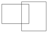
Question 32. The figure represents which type of error in GIS?The Figure Represents Which Type Of Error In GIS?
  1.    Pseudo node
  2.    Silver polygon
  3.    Dongle node
  4.    Poly line feature
 Discuss Question
Answer: Option B. -> Silver polygon
Answer: (b).Silver polygon
Question 33. Swiss Alps farming can be monitored by using ________
  1.    Revit
  2.    Remote sensing
  3.    GIS
  4.    Auto CAD
 Discuss Question
Answer: Option C. -> GIS
Answer: (c).GIS
Question 34. ESB integration model is developed based on __________
  1.    CIM series
  2.    GIS
  3.    Remote sensing
  4.    Arc GIS
 Discuss Question
Answer: Option A. -> CIM series
Answer: (a).CIM series
Question 35. The figure given below represents which topological error?The Figure Given Below Represents Which Topological Error?
  1.    Pseudo nodes
  2.    Silver polygon
  3.    Dongle nodes
  4.    Polygonal feature
 Discuss Question
Answer: Option A. -> Pseudo nodes
Answer: (a).Pseudo nodes
Question 36. Dongle nodes can be removed by ___________
  1.    Undo
  2.    Eraser
  3.    Behind shoot
  4.    Over shoot
 Discuss Question
Answer: Option D. -> Over shoot
Answer: (d).Over shoot
Question 37. Which of the following can be represented as an example of format error?
  1.    Silver polygons
  2.    Dongle nodes
  3.    Changing from raster to vector
  4.    Areal cover
 Discuss Question
Answer: Option C. -> Changing from raster to vector
Answer: (c).Changing from raster to vector
Question 38. Silver polygons occur due to excessive overlaying.
  1.    True
  2.    False
  3.    May be True or False
  4.    Can't say
 Discuss Question
Answer: Option A. -> True
Answer: (a).True
Question 39. Which of the following sets represent the correct set of map classification?
  1.    Cadastral, thematic
  2.    Thematic, geographic
  3.    Cadastral, geographic
  4.    Geographic, topographic
 Discuss Question
Answer: Option A. -> Cadastral, thematic
Answer: (a).Cadastral, thematic
Question 40. Which of the following can be used for representing a real world feature on two dimensional surfaces?
  1.    Plan
  2.    Drawing
  3.    Scale
  4.    Map
 Discuss Question
Answer: Option D. -> Map
Answer: (d).Map

Latest Videos

Latest Test Papers