Sail E0 Webinar
Question
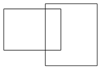
The figure represents which type of error in GIS?The Figure Represents Which Type Of Error In GIS?
Options:
A .  Pseudo node
B .  Silver polygon
C .  Dongle node
D .  Poly line feature
Answer: Option B
Answer: (b).Silver polygon

Was this answer helpful ?
Next Question

Submit Solution

Your email address will not be published. Required fields are marked *

Latest Videos

Latest Test Papers